PALI LEHOHLA | The grid and the covenant: how Silvertown redeemed the South African census
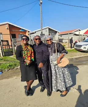
On Saturday, Nobutho Mpetsheni sent me a picture showing her at a funeral in Silvertown. In her company is a would-be Census 2011 employee who was subsequently recruited for further training by StatsSA and is now a contract employee of the agency.
Silvertown , a community in KwaZakhele , Gqeberha (then Port Elizabeth), named after the shiny tin houses ― freezing in winter and boiling in summer ― refused to be counted in the 2011 Census. The community took us on as StatsSA and nearly collapsed the census.
I had just enumerated the father of the nation in Qunu. The monumental questionnaire session with Madiba elevated me to a powerful position in the eyes of the shack-dwellers of Silvertown. It appears they had just won gold and a week later bestowed on me this power I’d never realised I had. That’s when I confronted their wrath.
They refused to be counted unless I brought their councillor back so that they could hold him to account. My claim of no power fell on deaf ears. Little did I realise the power of the wisdom of communities who seamlessly fuse their condition as one lived experience devoid of bureaucracies.
The census in a developing nation is rarely a benign bureaucratic exercise. It is often a contested battleground of identity, resource allocation and visibility. For decades, official planning within South Africa’s informal settlements, particularly those like Silvertown, had been predicated on a spatial fiction. When official maps are static, bureaucratic models become computational echo chambers that fail to capture community shift, growth and survival. Silvertown, before 2011, was effectively governed by a data ghost.
In October 2011, South Africa embarked on its third post-apartheid population count. For Silvertown, the stakes were existential. Decades of official planning had been stuck in a methodology of stagnation.
Our analysis of census data from 1996 through 2001 exposes this methodological rot. Across crucial quality-of-life indicators — housing quality, water access, sanitation, education and the multidimensional poverty index — the spatial patterns generated by subsequent census planning were, shockingly, visually identical “clones” of the 1996 baseline map.
Global Moran’s I, a key spatial statistic measuring inequality and clustering, remained stubbornly high and unchanged (I = 0.72 for housing in 1996; near-identical values projected for 2011 planning). This meant that the deep pockets of ‘High-High’ poverty and neglect identified in the very first post-apartheid census were simply projected forward in time.
Bureaucratic inertia missed the explosive growth of new informal settlements, ignored the failure of infrastructure in previously stable areas and validated a state of stagnation by failing to even measure the need for change. In Silvertown, residents were invisible because the grid had already been drawn and they weren’t on it.
The realisation that the community was being managed by a simulation sparked a revolt of active citizenship. Silvertown refused to accept its bureaucratic erasure.
5News aggregated this summary from the outlet’s public feed. The full article, with all the context, is on www.timeslive.co.za — the content belongs to TimesLIVE.